
Not long ago, Downtown Miami was an empty expanse of vacant lots, warehouses and nightclubs. While some of the nightclubs still remain, the area has come a long way in the past 5 years. Mixed use projects like Miami World Center and a privately funded intercity rail station, Miami Central Station, are serving as catalytic anchors and transforming the neighborhood. New condominium and apartment projects are also in various stages of development in Miami’s core.
While downtown’s land uses are transforming, its streets have mostly remained the same – a lot of 3 lane, one-way pairs with occasional 2 lane one way and two way streets. The 3 lane one-ways were designed during an era which prioritized moving through traffic into and out of Miami’s core as quickly as possible. There wasn’t much foot or bike traffic during this time, nor many amenities which people would want to visit in the area, so these cross sections made sense when they were designed decades ago.
There are a handful of bike lanes in Brickell just south of the CBD, where most of the development activity has taken place in the past decade, but many streets still use the same 3 lane cross section even in high pedestrian and cycling traffic areas like Brickell City Centre.
Some of these 3 lane, one-way pairs may still be justified, but I’m betting many are operating under-capacity and can safely be redesigned with more space for landscaping, wider sidewalks or bicycle facilities. Reallocating automobile lanes towards other uses requires consideration of many factors – adjacent land uses, current and future traffic volumes, and a capacity assessment of the nearby roadway network. Given downtown’s current transit access, future transit projects and increasing density, however, an incremental 3 to 2 lane conversion scheme should be possible for at least a handful of downtown streets.
The most recent Miami City Bike Plan recommends a collection of sharrows and shared lanes on downtown streets. Since this plan is dated and sharrows are no longer considered bike infrastructure, I don’t take this recommendation seriously. The Miami-Dade County 2040 Bicycle/Pedestrian Plan takes things a bit further, with a road diet and protected bike lane recommended on Miami Avenue/NE 1st Avenue. The plan is largely silent on design options for Downtown Miami streets, though.
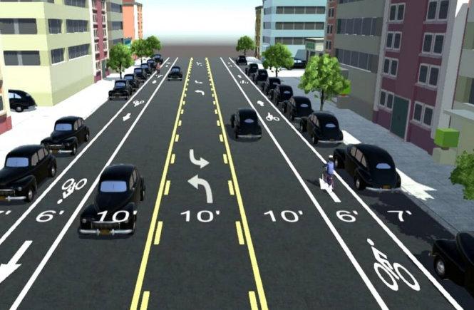
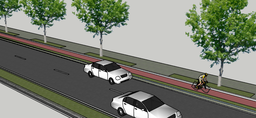
One possible design alternative is to convert the third lane into a single direction cycle track on several one way pairs. Assuming existing 11′ traffic lanes, a 7′ wide cycle track with a 4′ landscaped buffer would help remake these streets into safer, multi-modal public spaces. Cyclists would have more protection from automobiles, pedestrians would have slower traffic and shorter crossing distances due to a more narrow roadway, and everyone would have a safer, more pleasant street. Scooter riders and other micro-mobility users would be happy, too.
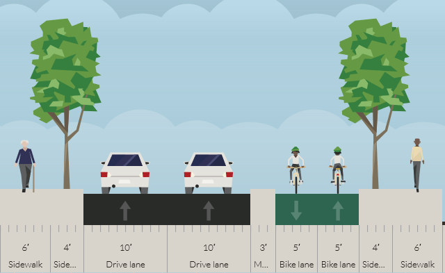
Another possibility for some downtown streets is a two way cycle track on one side of the street and narrowing the travel lanes down to 10′. While two way cycle tracks are not an ideal solution due to signal issues and driver expectancy at driveways and intersections, there may be some streets with minimal curb cuts and intersections where this cross section could be appropriate.
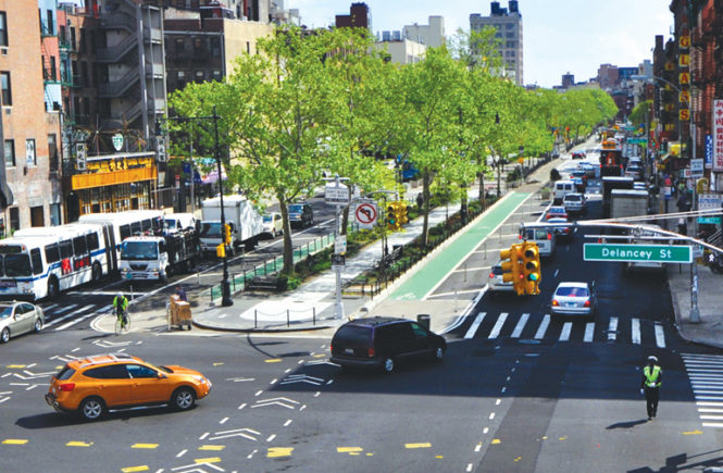
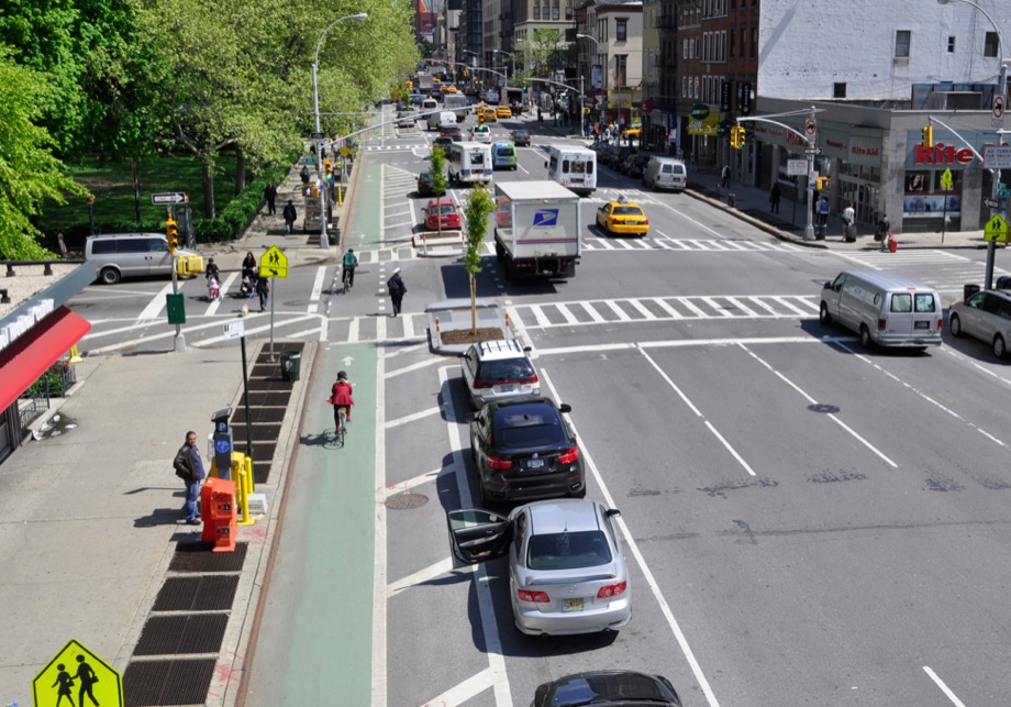
Parking protected bike lanes could also be used on select streets where parallel parking already exists. A 6′ bike lane with a 4′ or 5′ buffer between the bike lane and the parking lane is a great way to accommodate cyclists and still provide on-street parking. Here is an example from New York City.
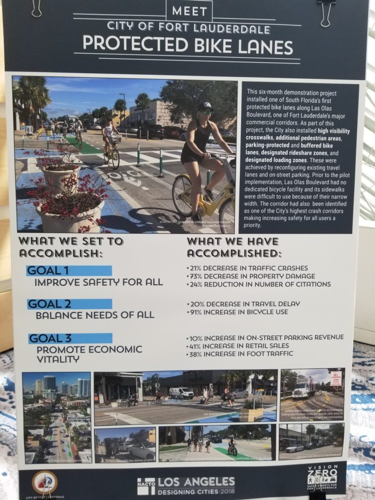
Real world results of already-built cycle tracks show increased bike ridership and safety benefits for protected facilities. A cycle track built on 9th Ave. in New York City showed injuries decreasing by 56 percent for all roadway users and a significant increase in cycling after construction. In Fort Lauderdale, Las Olas Boulevard showed remarkable ridership and safety improvements after installation of a protected bike lane. Here is a project summary from the 2018 National Association of City Transportation Officials (NACTO) conference:
Redesigning mid-block cross sections is only half the battle. It’s easy to draw bike lanes on a street and ignore intersections. This is why NACTO recently published an intersection treatment guide which provides design recommendations for pedestrian and cycling safety at these critical links. Ideas from this guide should be used to complete downtown’s multi-modal network at its weakest and least safe points – intersections.
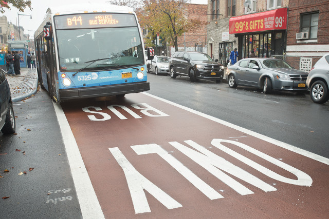
In light of Miami’s recent bus network redesign plan, there’s also an opportunity to make buses run more efficiently with dedicated bus lanes on select streets. This option represents the lowest-cost alternative to increase roadway capacity while supporting local and regional bus service.
Downtown Miami is in the middle of a renaissance with a surge of workers and residents occupying new development projects. With increased density comes more walking, biking and transit trips. Redesigning the neighborhood’s street network is a great opportunity to support this mode change while meeting Miami’s sustainability and traffic safety goals.