The City of Miami recently built a protected bike lane network downtown which provides needed access for the increasing number of people on scooters, e-bikes and traditional bikes. Unfortunately, this network mostly ends at the Miami River, with Brickell riders having to fend for themselves as they navigate streets which are inhospitable to cyclists. While the Underline provides a great north-south spine for pedestrians and cyclists through the neighborhood, getting to other nearby destinations requires one to either ride on the sidewalk or cycle in high speed traffic. Pedestrian safety issues, such as turning vehicle conflicts during “Walk” signals and lack of appropriate traffic control at some intersections, are also a problem. As the densest neighborhood in Florida which continues to grow, Brickell needs better streets where people feel comfortable walking and biking.
The Miami Bike Plan hasn’t been updated since 2009, and while an update is in the works, I took it upon myself to come up with a suggested bike network for Brickell given my extensive experience riding in the neighborhood. The purpose of this core network is to facilitate micromobility and cyclist movement within Brickell, with additional connections to downtown and western neighborhoods in later phases. Here’s my pro bono napkin sketch of a phase 1 network.
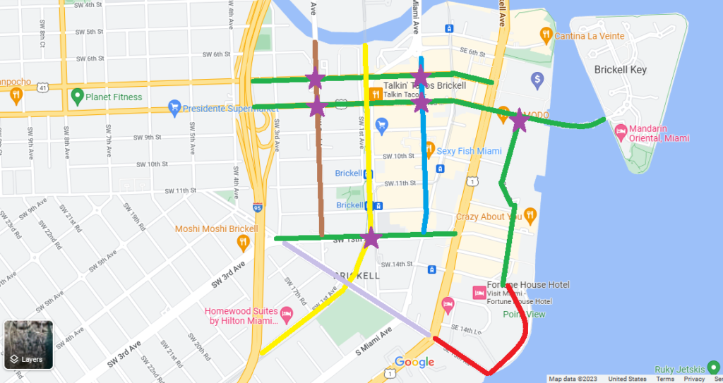
- Green Lines: Routes that will require lane repurposing to accommodate bike lanes.
- SW 7th and SW 8th One Way Couplet: 3 to 2 lane repurposing with the addition of protected bike lanes
- SW 8th bridge to Brickell Key: Lane repurposing with 2 westbound lanes, 1 eastbound lane and a protected bi-directional cycletrack
- SW 13th: 4 to 3 lane repurposing with traditional bike lanes and green paint (this will also make the SW 13th St. Underline crossing much safer for pedestrians)
- Brickell Bay Dr: 4 to 3 lane repurposing with traditional bike lanes and green paint. Why is this stub of a street even 4 lanes to begin with?
- Brown Line: SW 2nd Ave – Traffic control or traffic calming at all intersections so it functions as a local street. Green paint for existing bike lanes. I often see pedestrian/automobile conflicts on this street because of a lack of traffic control at intersections.
- Blue Line: S. Miami Ave – 2 way conversion, traffic control at intersections where there currently isn’t any, and raised intersections to create a bike boulevard. Long term: A woonerf similar to the one constructed on Flagler St.
- Lavender Line: SW 15th Rd – auto-lane narrowing, buffered bike lanes with green paint. Lots of fast traffic here because the lanes are 15′.
- Red Line: SW 15th Rd into waterfront Brickell Bay Dr. section – One lane of parallel parking removed for a bi-directional cycletrack.
- Yellow Line: Existing Underline with new raised crosswalks across SW 13th St. and SW 15th Rd
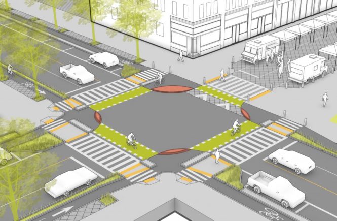
- Other purple stars: Pedestrian safety upgrades at intersections. This means leading pedestrian intervals, high visibility crosswalks, protected left turns, bumpouts, and possibly additional lighting.
A core bike network in Brickell will go a long way in improving safety for all roadway users and alleviating sidewalk congestion. Combined with targeted pedestrian safety countermeasures, Brickell could become a safer, more multimodal place, and a model for other Miami neighborhoods. Hoboken, NJ is a great model for quick win pedestrian safety upgrades. If a town adjacent to NYC can make these changes with the amount of traffic volume it has, so can Miami.